After the wedding in Bend, Oregon we started our trek home. We hadn’t been to Lake Tahoe in 28 years so we decided to venture back to our desert home the Tahoe way. It was a long drive with yet another alarm clock blaring way too early on vacation. Seriously, does anyone else set an “o-dark-thirty” alarm on vacation? We can’t be the only ones.
It was good to escape the choking smoke that is covering Oregon. While we were still in Bend, the big fire in the Columbia River Gorge was started by some kids playing with fireworks. At least that was the initial report. I’m sad that beautiful part of the state has been damaged so. We spent a day right after we were married driving up the Gorge checking out the waterfalls along the way. It has been on our list to see again but it will look completely different. The adventure will probably still be the same; set the alarm clock and hike to the top of as many as we can with me snapping pictures all along the way.
Onto Lake Tahoe. The smoke from the many fires in Northern California gave an almost eerie look to the mountains surrounding the lake. Sigh, another beautiful area affected by fire. Our GPS had us going “the long way” to Zephyr Cove Campground and Mark saw a faster way on Route 50 out of Carson City that would save us a lot of time. Okay, I’m ready to get out of the RV and enjoy a walk by the water in the rain. Well, halfway through the Rte. 50 pass, the GPS alerted us to a low bridge and my mind immediately went back to our little airport adventure the day we picked up the RV. Mark kept telling me not to worry because there were semis taller than us driving the same direction we were. He was right, the height restriction was for a rounded lakeside tunnel and the height issue was solved by driving in the center of the tunnel taking up both lanes. Thankfully there wasn’t much traffic and we didn’t impede anyone.
It rained almost the entire way from Carson City to the campground which made the coach a filthy mess again. We had glorious rain two of the three days we were there. Not all day rain thank goodness because we had hikes planned. The temps were nice and cool and let’s be honest, our temps are so hot in Arizona, I welcome anytime I can wear pants in the summer! We had a break in the thunderstorms so we took our Marlee dog on a big walk over by the lake. I think she was glad to get out of the RV, too.
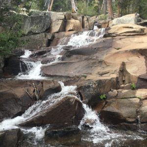
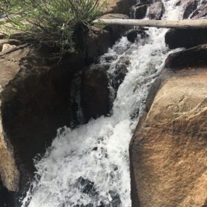
The campground had a nice activity magazine and we decided to start our hike in Emerald Bay. It’s a popular place and I’m glad we got there early. We hiked back to Cascade Falls. It was an easy hike, maybe three miles round trip with great views of Cascade Lake and Lake Tahoe. Cascade lake is teeny tiny next to the larger Lake Tahoe but is the perfect size to waterski on and not worry about a jetski running into you and your wake. There were a handful of houses with water toys on the lake. I could totally live in any one of them. We could see and hear the falls almost the entire way. Like everyone else, I love the sound of a waterfall. The hike did not disappoint. The water slides down large rocks and cascades over smaller ones until it finally cascades over the last few. I think I know where its name came from.

We climbed around on different rocks and made our way out to the edge where the water went over for the long drop. The sound of a waterfall is so soothing to me. The sound of the many little waterfalls as the water went down for the large fall is so relaxing. We spent a good amount of time just listening and looking around. We talked to a couple that said the last time they were here there was no water. That would be weird. I thought of Niagara Falls when it freezes and the area is suddenly quiet.
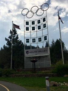 We’d planned more little hikes on our drive around the lake but the off and on thunderstorms threw a wrench in our plans. We had lunch in Tahoe City then drove to Squaw Valley where the 1960 Winter Olympics were held. We were hoping to be able to hike a little there but none of the lifts were running. It’s fun to take the ski lift and see the mountain in a completely different way from when we ski and walk down the runs we normally ski down. There are two large signs at the entrance with the Olympic Rings and the flame. I really like that torch is still burning all these years later.
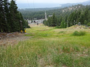
We mapped out two bigger hikes for our second and last day there. We opted to hike Heavenly. We use the AllTrails App for both hiking and RZR rides and the hike at Heavenly Ski Resort looked like a good one; 10 miles with a 2,000 foot elevation gain. Woo-Hoo! A good calorie burn! The mountain is officially closed but you can walk/hike and they don’t mind. The trail started from the base of the California Station parking lot and went straight up the ski run to the cat trail used for grooming and rescue during ski season. When I say straight up, I mean straight up with a narrow, not too defined trail either. Great, straight up. We’ve had straight up before in Telluride and it’s my all-time favorite ski run hike but Telluride is open for hikers in the summer and maintains the trails. I repeated this phrase in my head for this first part was: put your head down and don’t stop. The rest was all on the cat trail and we had the place to ourselves except for the resort and utilities workers going up and down. There were some very steep parts but it was manageable. We reached the mid-mountain set of lifts and the cat trail went in two directions, straight ahead or up and to the left. The app, however went up and to the right. There was literally no trail but someone had done it and marked it on the app. Up and to the right we went. I thought the first part from the parking lot was steep, but holy cow. This had to be a double black diamond run in the winter it was so steep. I don’t ski those runs, why was I hiking one now. Mark really wanted the view at the top so I pressed on. The ski run turned up and to the left and my heart sank. We still had a long (LONG) way to go. We normally chat on our hikes, pointing out different sights and animals but we were both strangely quiet on this ski run. I was so happy when Mark saw the next steep part and said that we probably shouldn’t continue. This was more than we bargained for and since we were all by ourselves, probably not smart to continue. I jumped for joy inside because this part wasn’t fun anymore. We went back down to the mid-mountain area and took the cat trail that went up and to the left and found where all those trucks had been going. We found a bench at the top of this mountain above the maintenance yard to eat lunch and enjoy the view of Lake Tahoe.
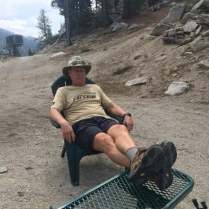
Many of the cat trails are somewhat flat and snowboarders have trouble keeping speed. Not these cat trails. There were parts that I zig-zagged the walk down. I wouldn’t ever have to put my ski pole out to a snowboarder and try to slingshot them down any of these cat trails. As we got closer to the ski run we walked up, I told Mark that I’d rather continue walking down the cat trail until it ended and walk down the road up ahead. Thankfully he agreed. He’s hiking on a torn meniscus and will have surgery soon. All totaled, we covered 8 miles and I burned 1,338 calories. Yeah!
Mark iced his knee when we got back and we had brownies with ice cream as a post hike treat. Yum. Our time in Tahoe was done and the alarm would greet us again in the morning for our next stop in Lone Pine, CA.